When we are assigned an area to dig it is generally with some particular questions in mind. Here is our current assignment:
On the far left peeking out from behind the wheelbarrow is the wall of the fort. The mounded up earth adjacent to it is what is called the rampart. It acted as internal support for the walls and gave access to soldiers who were manning the wall. In theory the rampart was a wide clear area. But in the late Roman era there were all sorts of buildings, ovens and other structures edging out onto the rampart area. The fort was crowded as (presumably) the civilian population from the now abandoned village had moved inside. So amoung other things we really don't know what that line of big flagstones was all about. Pete and I are excavating what should be the ring road around the inside of the rampart. Our current excavations go to the right off and back from the yellow bucket.
The dark murky soil does not resemble roadway yet. It in fact gives you vivid images of just what was squelching around the toes of late Roman and post Roman inhabitants.
And down in the soil we find things like this:
A rather nice pottery vessel, broken, coming up.
This image pretty much explains itself. Sheep I think.
Another nice broken pot, of the type called Samian ware.
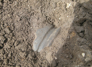
But some things look the same one millenium to the next. Even 1800 year old glass still looks like glass.


No comments:
Post a Comment